
WGCG has designed and erected interpretation panels which describe the local geology in an accessible way to the public at these locations:
<– Please click the thumbnail on the left or click here to see the full-screen PDF in a new window.
The WGCG Ryton Pools leaflet ‘Exploring the Landscape Trail’ is available at the Ryton Pools Country Park Visitor Centre.
WGCG’s older Ice Age leaflets are no longer in print but can be seen as PDFs in the Leaflets section on this website, as can the ‘Exploring The Landscape Trail’ leaflet.
Location: Ryton Pools Country Park Ryton Road, Coventry, Warwickshire CV8 3BH

Geo Wall at Brandon Marsh Interpretation Panel info.
Lots more info and photos at: The Rocks of Warwickshire as represented in the Geology Wall at Brandon Marsh
<– Please click the thumbnail on the left to see the full-screen PDF in a new window.
Location: Brandon Marsh Nature Reserve, Brandon Ln, Coventry CV3 3GW

Geo Wall at Brandon Marsh Time Line info.
Lots more info and photos at: The Rocks of Warwickshire as represented in the Geology Wall at Brandon Marsh
<– Please click the thumbnail on the left to see the full-screen PDF in a new window.
Location: Brandon Marsh Nature Reserve, Brandon Ln, Coventry CV3 3GW

Ufton Fields is a SSSI and managed by Warwickshire Wildlife Trust (WWT). Their panel with SSSI information and interpretation is installed at Ufton Fields and shown here, courtesy of WWT. For Ufton Fields, the WWT website has Visitor Information and Wild Walks
WGCG has extensive and very interesting geological information on Ufton Fields. Please see at: WGCG Conservation at Ufton Fields The focus of the geological interest is an outcrop of unquarried White Lias Limestone (Langport Member) which warrants conservation and designation as a Local Geological Site (LGS) because there are now very few such exposures, accessible or otherwise, in Warwickshire.
<– Please click the thumbnail on the left or here to see the full-screen PDF in a new window.
Location: Ufton Fields, Leamington Spa CV33 9NY – OS Map Reference SP 378 615

Kenilworth Cutting Interpretation Panel info. More to follow.
See more information on: Kenilworth Cutting
<– Please click the thumbnail on the left to see the full-screen PDF in a new window.

Burton Dassett Hills Country Park
Conservation Committee has started on a project to design three interpretation boards for the Burton Dassett Hills Country Park. The first is now designed and was erected with the co-operation of the WCC Ranger for the hills. The themes for the other two boards are “The Park and the wider geology and landscape” (essentially what you can see from the Hills) and “The iron mining industry”. The Burton Dassett Hills are Local Geological Site 33 and information can be found in the LGS section of our website. See our page on The Burton Dassett Hills Country Park geology.
<– Please click the thumbnail on the left to see the full-screen PDF in a new window.

The Group was funded by the Local Heritage Initiative Fund to produce geological interpretation boards and displays of the geology of Warwickshire at the Parkridge Centre in conjunction with the Warwickshire Wildlife Trust.
Location: Parkridge Centre, Brueton Park Solihull, Warwickshire B91 3HW.
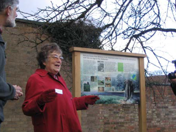
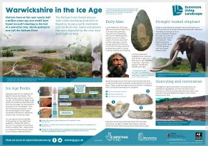
As part of an Aggregate Levy Sustainability Fund supported project, an interpretation board has been installed on Wolston Village Green. This illustrates the environment that existed in the area about 500,000 years ago. See an article from our 2007 spring newsletter for more about this panel.
Location: Main Street, Wolston CV8 3HJ.
See also: Wikipedia page: Frederick William Shotton
See Photos of 25 April 2020 taken and supplied by Larry Wooding
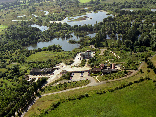
As part of an Aggregate Levy Sustainability Fund supported project, an interpretation board has been installed at Brandon Marsh Nature Reserve on a wall in the courtyard.
Location: Brandon Marsh Nature Reserve Coventry, Warwickshire CV8 3ET.

Interpretation Panels had been installed at four locations on the site. See an article from our 2007 spring newsletter for more about this location. Sadly these are no longer accessible to the public.
Location: Purley/Mancetter Quarry Quarry Lane Mancetter, Atherstone, Warwickshire CV9 2RF.